 June 26, 2026
 Categories: Photo of the Day
Hurricane Sandy on Oct. 29
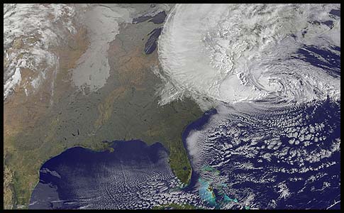


NOAA's GOES-13 satellite captured this visible image of Hurricane Sandy battering the U.S. East coast on Monday, Oct. 29 at 9:10 a.m. EDT. At 8 a.m. EDT the National Hurricane Center noted that the center of Hurricane Sandy was located near latitude 36.8 north and longitude 71.1 west. This was about 310 miles (505 km) south-southeast of New York City, and 265 miles (425 km) southeast of Atlantic City, N.J. Sandy was moving north-northwest at 20 mph. Maximum sustained winds are now near 85 mph (140 kph). Tropical Storm force winds extend almost 500 miles from the center, making those winds 1,000 miles in diameter. The image was created by the NASA GOES Project at NASA's Goddard Space Flight Center, Greenbelt, Md.